August 8-14, 2026
Temperature
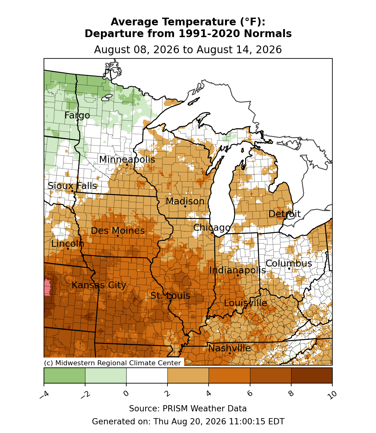
Temperatures were above normal by 4-6°F across southern and central Illinois, southern Iowa, southwestern Indiana, and Missouri (Figure 1). Some parts of Missouri and Illinois were up to 8°F above normal. The rest of the region was just slightly above normal, while parts of Minnesota were near to slightly below normal.
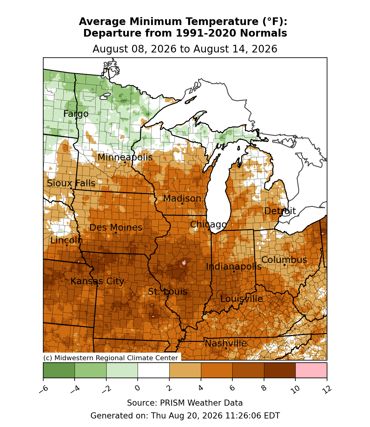
Minimum temperatures were mostly above normal, save Michigan’s Upper Peninsula (UP) and northern Minnesota, where temperatures were slightly below normal (Figure 2). In Illinois, Indiana, and Missouri, many areas were 6-8°F above normal for minimum temperatures for the week. Other areas were generally 3-6°F above normal.
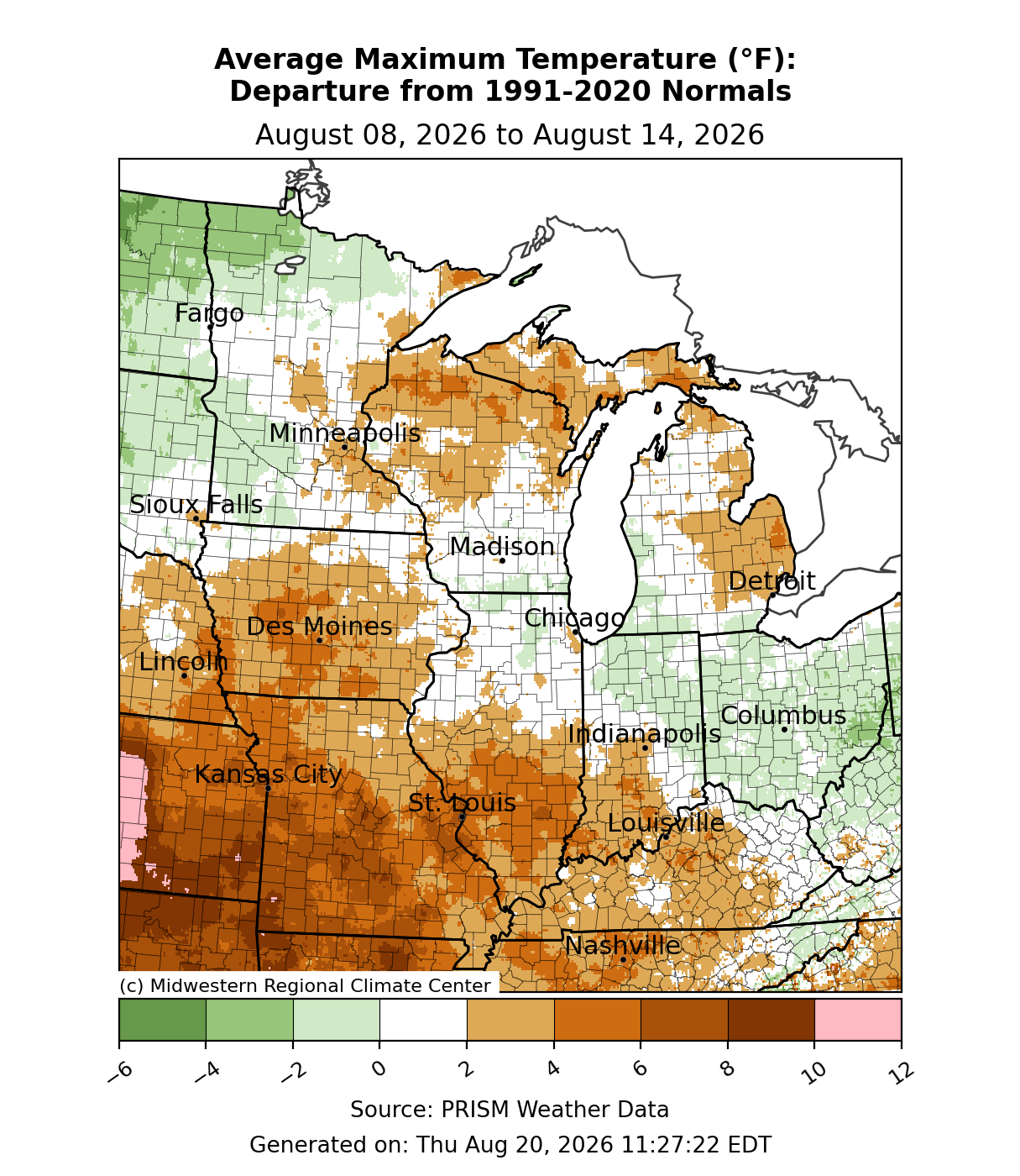
Maximum temperatures were less anomalous. Most of the region observed temperatures that were near normal, whether slightly above or below normal (Figure 3). Exceptions were in Iowa, Missouri, southern Illinois, southwestern Indiana, and Kentucky, where temperatures were 2-6°F above normal. In the Upper Midwest, eastern Michigan, the UP, and northern Wisconsin were also 2-4°F above normal.
Precipitation/Drought
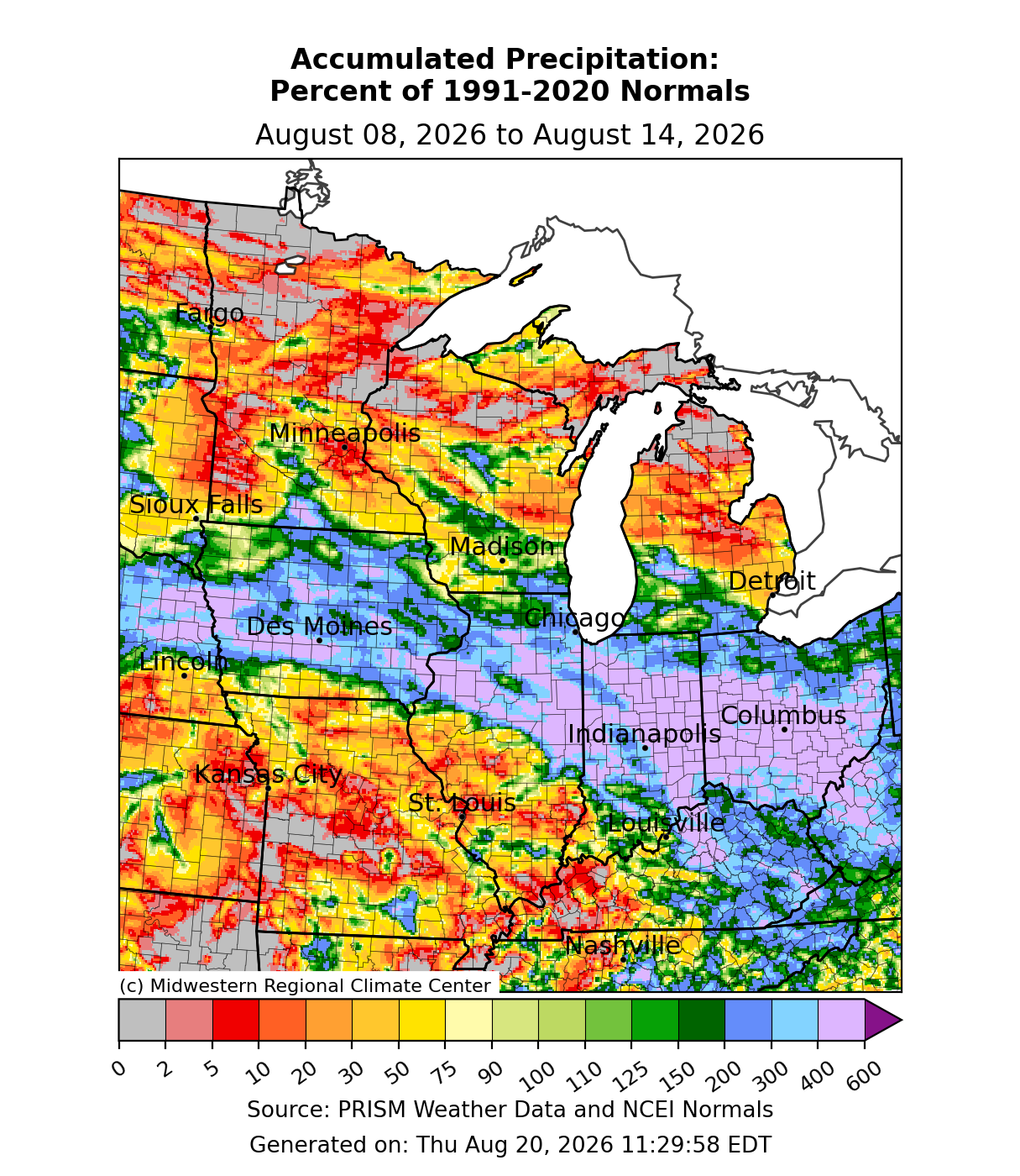
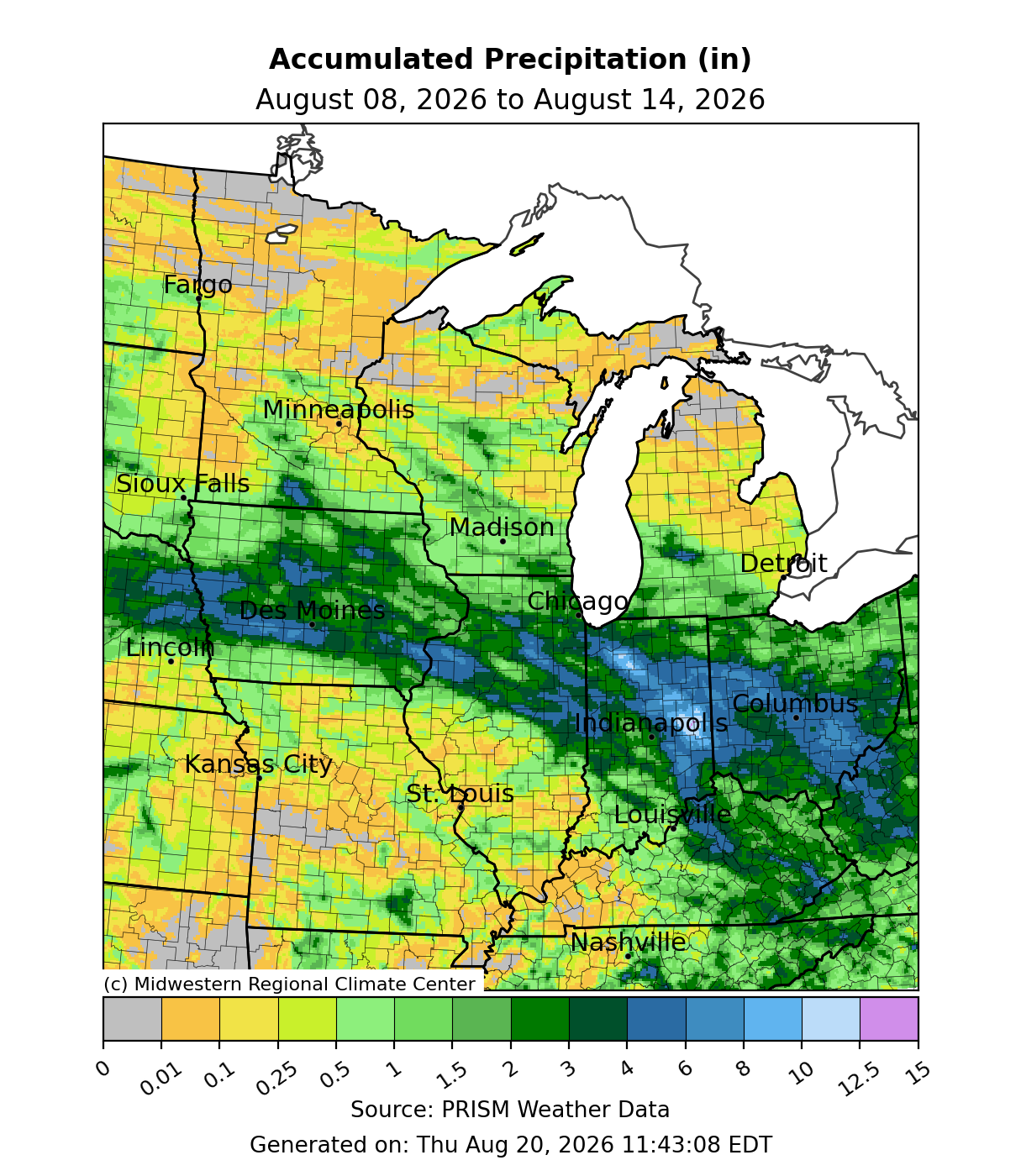
Precipitation was both significant and insignificant for a large swath of the region. For much of the Upper Midwest and the far southern parts of the region, Missouri, southern Illinois, and western Kentucky, precipitation was lackluster. In contrast, a front held nearly stationary from Iowa through Indiana, allowing rain to train over certain areas. Along and south of I-80 through Iowa, Illinois, Indiana, and Ohio, precipitation was generally 300-400+ percent of normal (Figure 4). Some of the aforementioned states had locations that received over 6 inches of rain within hours, and isolated locations across Indiana received over 10 inches of rain (Figure 5).
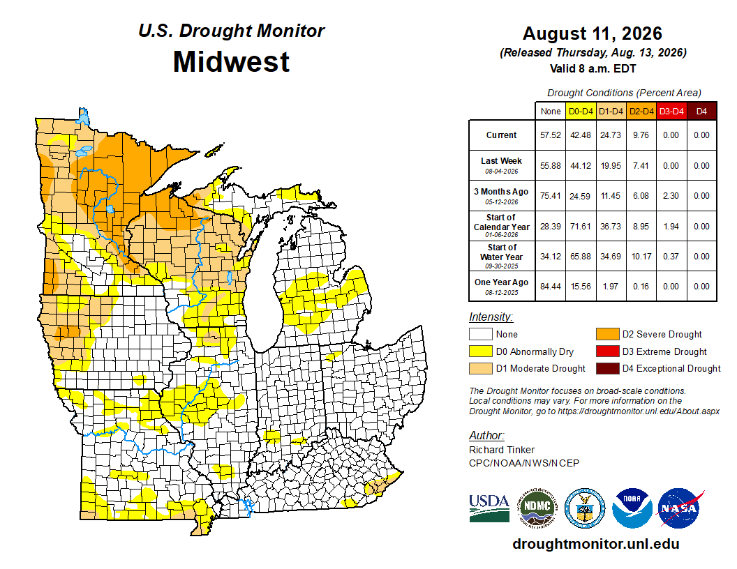
Overall percent coverage in drought conditions did not change much, as drought expansion in some areas was offset by drought removal in others. There were expansions in D0 (abnormally dry) across many western parts of the region (Figure 6). In Minnesota and Wisconsin, D1 (moderate drought) was expanded. In Minnesota, D2 (severe drought) expanded by over 10 percent to cover nearly 45 percent of the state.
Extreme Rain and Flooding Across Indiana- August 12
The wet pattern produced significant impacts across Indiana in particular. Several local weather stations set new records or came close to longstanding single-day precipitation records. In New Castle, where 7.74 inches of rain fell on August 12, making it the wettest day in New Castle since records began in 1949. For New Castle, this was considered a 1000-year rainfall event. In Muncie, 5.99 inches of rain fell on August 12, the second-greatest single-day precipitation total there since records began in 1946. For Muncie, this was considered a 200-year rainfall event.
Significant impacts were felt across Indiana. The White River at Anderson, Indiana had its all-time highest crest when the river rose to 24.93 feet, over a foot higher than the prior record set during the Great Flood of 1913. Similarly, the White River at Noblesville set the all-time highest crest when the river rose to 24.60, nearly a foot higher than the Great Flood of 1913. In Anderson, flooded roadways prompted evacuations and water rescues. In Carmel, a bridge collapsed which led to concerns that rising waters along the White River could cause a sewer line to fail and spew wastewater into the river. A portion of I-70 westbound in Wayne County collapsed as rising water overtook the westbound lanes.
Severe Weather & August 11 Derecho
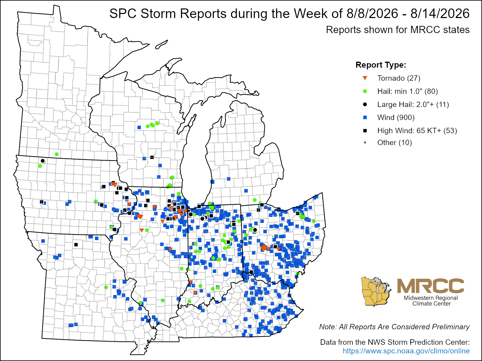
There were just over 1,000 reports of severe weather this week, with the vast majority of them—900—coming in as wind reports (Figure 7). There were also 80 hail reports and 27 tornado reports. The most significant impacts came from a derecho that moved across the region on August 11. This event produced 8 tornadoes ranging in strength from EF0 to EF2. However, straight-line winds were just as noteworthy, with gusts exceeding 80 mph reported across the Chicagoland area. An 89-mph straight-line wind gust was reported at a private weather station in Kane County, Illinois. An 85-mph straight-line wind gust was observed at Aurora’s Sugar Grove Airport. Widespread tree damage occurred when trees with 1–3-foot diameters were uprooted in several forested preserves across DuPage County, Illinois. In Lake County, Indiana, a woman was struck and killed by roofing debris. At one point, at least 95% of Lake County, which includes the cities of Gary and Hammond, was without power. In Clark County, Ohio, an EF0 tornado with estimated peak winds of 80 mph flipped a semi-trailer.